
Tropical volcanic islands are biodiversity hotspots where the Critical Zone (CZ) remains poorly studied. In such steep topographic environments associated with extreme climatic events (cyclones), deploying and maintaining monitoring equipment is highly challenging. While a few CZ Observatories (CZO) are located in tropical volcanic regions, none of them includes a Tropical Montane Cloud Forest (TMCF) at the watershed scale, which is essential for water regulation, biodiversity, and maintaining healthy ecosystems.
This case study presents the dataset from the ERORUN-STAFOR observatory—newly named the Observatory of the Critical Zone of La Réunion (OZC-R)—which is the first observatory that integrated a TMCF within the French network of CRZ: Research and Application (OZCAR, www.ozcar-ri.org).
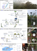
This collaborative observatory is located in the northern part of La Réunion Island within the 45.0 km² (17.375 mi²) watershed of Rivière des Pluies (i.e., Rainfall River), which hosts the TMCF of Plaines des Fougères, one of the best preserved natural habitats in La Réunion Island. Monitoring and data collection began in 2014, with local partners assisting, and continual instrumentation improvements were made over time.
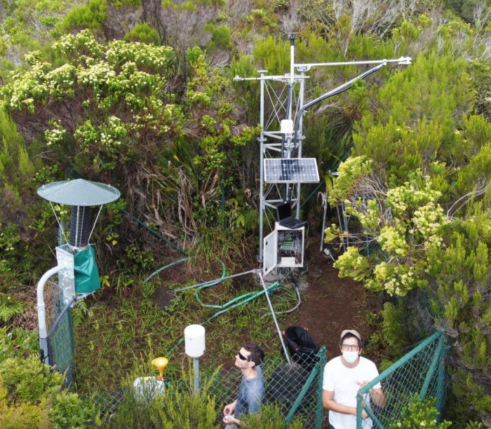
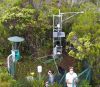
At the watershed scale and in its vicinity, this observatory includes ten measurement stations covering the upstream, midstream, and downstream parts of the watershed. The stations record a total of 48 different variables through continuous (sensors) or periodic (sampling) monitoring. The dataset consists of continuous time-series variables related to:
- Meteorology – precipitation, air temperature, relative humidity, wind speed and direction, net radiation, atmospheric pressure, cloud water flux, irradiance, leaf wetness, and soil temperature
- Hydrology – water level and temperature, and discharge and electrical conductivity (EC) of stream
- Hydrogeology – groundwater level, water temperature and EC in two piezometers and one horizontally drilled groundwater gallery completed by soil moisture measurements under the canopy
- Hydrogeochemistry – field parameters and water analysis results
The periodic sampling survey provides chemical and isotopic compositions of rainfall, groundwater, and stream water at different watershed locations. This dataset extends from 2014 to 2022 with an acquisition frequency from ten minutes to hourly for the sensor variables, and from weekly to monthly frequency for the sampling.
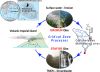
Despite the frequent maintenance of the monitoring sites, several data gaps exist due to the remote location of some sites and instrument destruction by cyclones. Preliminary results show that the Rivière des Pluies watershed is characterized by high annual precipitation—greater than 3,000 mm/y (118.11 in.)—and a fast hydrologic response to precipitation (approximately two hours basin lag time). The long-term evolution of the deep groundwater recharge is mainly driven by the occurrence of cyclone events with a seasonal groundwater response. The water chemical results support existing hydrogeological conceptual models, suggesting a deep infiltration of the upstream infiltrated rainfall. The TMCF of Plaine des Fougères shows a high water-storage capacity (greater than 2,000% for the bryophytes) that makes this a significant input of water-to-groundwater recharge, which still needs to be quantified. This observatory is a unique research site in an insular volcanic tropical environment offering three windows of observation for the study of CZ processes through upstream/midstream/downstream measurement sites.
This high-resolution dataset is valuable to assess the response of volcanic tropical watersheds and aquifers at both event and long-term scales (i.e., global change). It will also provide insights in the hydrogeological conceptual model of volcanic islands, including the significant role of the TMCFs in the recharge processes as well as the watershed hydrosedimentary responses to extreme climatic events and their respective evolution under changing climatic conditions.
In addition to supplying a large part of the equipment, Stratagem974, by request of OZC-R, has made data storage and transmission more reliable by setting up a local network between stations outside and under the canopy to centralize data at the station capable of transmitting data via GPRS. As part of the research work, the Campbell Scientific SoilVue™10 was made available from November 2020 to February 2022 to validate its data.
All data sets are available at https://doi.org/10.5281/zenodo.7983138.
Zusammenfassung Projekt
Anwendung
Multidisciplinary research for meteorology, hydrology, hygrogeology, and hydrogeochemistryStandort
Réunion IslandVerwendete Produkte
SKP215 WINDSONIC4 CS100 NR01 CS125 NL120 TCAV-L NL115 CS616 SoilVUE10 CR1000Autoren
Stratagem974Gemessene Parameter
Fog, wind speed and direction, net radiation, PAR quantum, air temperature, humidity, barometric pressure, rainfall, soil water potential, leaf wetness, soil temperature, water temperature, volumetric soil water content, water levelpdf anzeigen